|
| |
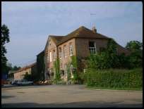
 Sheffield Park in East Sussex lies on the East Grinstead to Lewes road, the name and
village were created by Lord Sheffield. Sheffield Park in East Sussex lies on the East Grinstead to Lewes road, the name and
village were created by Lord Sheffield.
In 1769 John Baker Holroyd bought and moved moved into the large estate ,
which after he become the First Lord Sheffield was renamed Sheffield Park .
The Park was created by John , who employed Capability Brown and
Humphrey Repton to design the gardens and estate.
In 1790 the Upper Ouse Navigation Trustees were created to provide the
Ouse valley with a navigable water route to transport goods by barge
to and from the coast. About 1880 the waterway was superceeded by the
railway line and fell into decline.
The author Edward Gibbons who wrote 'The Decline and Fall of the Roman Empire'
would stay with the Sheffield family on a regular basis, and when he died was
buried in nearby Fletching church in 1794.
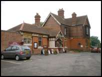
In 1876 the Lewes and East Grinstead Railway was formed, to provide the
Sheffield family and their guests with transport to and from the estate.
It was originally called Fletching station, but renamed due to
Lord Sheffield's insistence. The line was closed during in 1956 and taken
over by the Bluebell Railway Preservation Society who now run steam trains from
Sheffield Park to Horsted Keynes , with plans to extend to East Grinstead .
In 1898 Albert Turner came to the area to set up a sawmill on the river
Ouse, after damming the Ouse and trying out the mills he found that
there was not enough power to run the mill, and so set up a steam engine
to provide the horsepower, the mill still exists. |
|
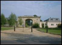
 Sheffield Park in East Sussex is owned by the National Trust , and is open to the
public to view the estate. Sheffield Park in East Sussex is owned by the National Trust , and is open to the
public to view the estate.
The Bluebell Line provides a glimpse at early 20th century life with
the steam trains running to Horsted Keynes . |
|
 The nearest village is Fletching at the other end of Sheffield Park in East Sussex . The nearest village is Fletching at the other end of Sheffield Park in East Sussex .
The nearest main shops are at East Grinstead about 10 miles to the
north , Lewes about 10 miles south or Haywards Heath about 5 miles west. |
|
| Sheffield Park is shown as the red symbol on the map. |
|
|
Nearby Villages
(click on symbol to see the village page) |
| Village= | |
Town= | |
Recorded in Domesday= |  |
| |
|
|
Blackboys |
(Charcoal and Soot) | | 6.83 miles |
|
|
Buxted |
(The first Iron Cannon in England) | | 5.44 miles |
|
|
Chelwood Gate |
The Forest entrance and President Kennedy | | 3.07 miles |
|
|
Fairwarp |
(Charcoal and the Army) | | 3.74 miles |
|
|
Fletching |
(Simon de Montfort and Jack Cade) | | 1.32 miles |
|
|
Framfield |
(380 years without a church tower) | | 5.86 miles |
|
|
Maresfield |
(Soldiers and Iron) | | 3.41 miles |
|
|
Newick |
(Killer Cricket and Dirk Bogarde) | | 2.03 miles |
|
|
Nutley |
(Edward III and the Post Mill) | | 2.73 miles |
|
|
Piltdown |
(The Piltdown Man hoax) | | 2.71 miles |
|
|
Uckfield |
(Traction Engine destroys bridge) | | 4.58 miles |
|
|


